Community
Corners Connector Trail System: Connecting Places Where People Live, Work, and Play


Peachtree Corners is fortunate to have amazing outdoor amenities we can all enjoy, such as the Chattahoochee River, federal and county parks, streams and a thick tree canopy. Everyone who enjoys being outside takes advantage of those areas of our community. The City intends to create even more of an advantage for our citizens by connecting these wonderful features together with its multi-use trail system, the Corners Connector.
The Corners Connector Trail System will one day consist of over 11 miles of trails that crisscross the city and provide connections to a variety of places people live, work and play. But to be successful, the trail system will need two essential elements: good locations and available funding. Here is an update on where we are on the Corners Connector Trail System.
Over the last six years, a number of location and feasibility studies have been completed that serve as the foundation of planning for the ultimate build-out of this trail. The Peachtree Corners Livable Centers Initiative, finished in February 2015 and funded by the Atlanta Regional Commission (ARC), was one of the first projects that identified this ultimate trail system.

That project was followed later by studies for the Winters Chapel Road and Holcomb Bridge Road corridors. Later, the Comprehensive Transportation Plan, Innovation Hub Master Plan and the Innovative District Trails Study reinforced and further developed the idea of a master trail system in Peachtree Corners. Most recently, the ARC funded a study of feasibility on a specific segment and location of the Corners Connector along Crooked Creek from Spalding Drive east to Peachtree Parkway.
The Corners Connector Crooked Creek project is a long-range plan that will ultimately provide nearly three miles of trail at a cost of approximately $13 million. This project involves environmental permitting and procurement of easements, so the timeline is fairly lengthy.
In the shorter term, the City is pursuing federal funding for a segment of the trail from Peachtree Corners Circle to Peachtree Parkway, which is approximately 7,400 feet in length. The hope is to obtain funding for planning, engineering and construction of this segment as a first phase of the ultimate project that extends all the way to Spalding Drive.
The ultimate buildout of the Corners Connector is an exciting goal over the coming years, but some segments of the Connector have already been completed. Corners Connector Tech Park Lake was completed in 2020 and includes over 1,600 feet of trail around the lake adjacent to Technology Parkway and Technology Parkway South. This segment connects to over 4,300 feet of the Connector along Technology Parkway and Engineering Drive. Phase II of the Corners Connector around the lake is under planning and development now, and it will complete the circuit around the lake with an additional 2,600 feet of trail and provide an even greater amenity to those residents who live nearby and the office workers who enjoy direct access.
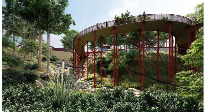
Corners Connector Town Center is under construction now. This project is directly adjacent to the recently completed pedestrian bridge over Peachtree Parkway and the Lazy Dog Restaurant. This trail will connect those areas to the eastern most portions of the Town Center and Town Green, along with connections to Peachtree Corners Circle and the development to the south of the stream. Stream connections and a boardwalk along the stream’s banks are included, along with a skywalk segment that will provide a bird’s eye view of the stream below. It will add 2,400 feet to the Corners Connector system, and with its connection to Peachtree Corners Circle, the system will then have a connection along Medlock Bridge Road and South Old Peachtree Road to existing multi-use trails in Duluth.
Corners Connector Engineering Trail is another segment under development. This portion of the system is proposed to connect Engineering Drive south to Woodhill Drive for approximately 4,900 feet of additional trail. An existing segment of the Corners Connector currently ends at Engineering Drive and Peachtree Parkway in front of the Corners Fine Wine & Spirits and RaceTrac, and this project will extend that trail infrastructure south to the Chick-fil-A area and its adjacent shopping centers.
The City is also in the planning and engineering phase of a segment of the Corners Connector along East Jones Bridge Road. This segment will connect Jones Bridge Park east to the existing multi-use trail along Peachtree Parkway. There is a narrow sidewalk along the shoulder of the road that will be enhanced to a 12’-14’ wide path to provide accommodations for more pedestrians and cyclists.
This project is part of the Chattahoochee Riverland, which includes a trail system that connects Newnan to the Buford Dam along the Chattahoochee River corridor (chattahoocheeriverlands.com). Our portion of the project along East Jones Bridge Road will be just over 9,200 feet long. We are excited to have a portion of such a large-scale project that will connect a number of jurisdictions to the remarkable Chattahoochee River amenity areas in the metro-Atlanta area.
A new opportunity for funding came to light recently when Congresswoman Carolyn Bordeaux held a press conference here at Jones Bridge Park recently to reveal her proposed national grant program to fund suburb greenway expansion.
The overa ll project called, FutureFit the Suburbs, has an initiative called the National & Regional Greenways Act, which would create a grant program to fund active transportation projects, including the construction and connection of national and regional greenways. This sounds promising and may offer an opportunity to have our tax dollars come back to our community! As you can see, exciting things are underway and already in place for Corners Connector, andmany more amazing additions are coming soon.
Stay safe,
Mayor Mike Mason